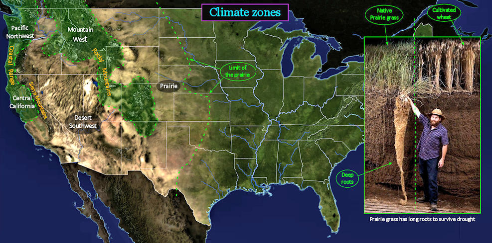
The West is DifferentMost of the West is dry country, but just how dry depends upon the region. The interior regions are both hot and dry, while the Pacific Coast has mountain ranges that blanket the region in frequent mist and rain. The prairie begins gradually, but ends abruptly at the Rocky Mountains. Native grasses thrive on the prairie, but few trees. The Mountain West, trending diagonally down towards Texas, is typically irrigated to grow cattle feed. Much of Central California, just inland of the coastal range, is highly irrigated to support intensive farming. Further inland, between the Sierra Mountains and Rocky Mountains, lies the bone-dry Desert Southwest. |
| ||||||||||||||||
| |||||||||
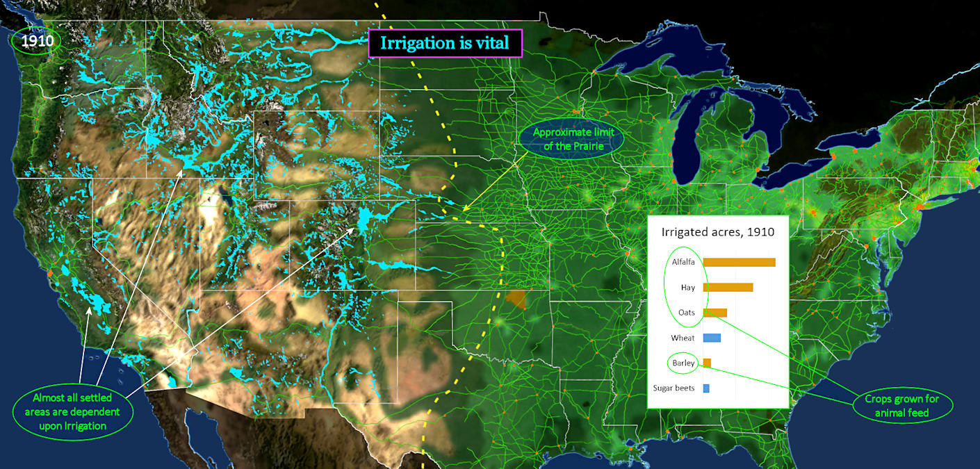
Feeding the Livestock BLUE highlights indicate zones being irrigated, which have tripled in acreage in the previous 20 years. Western areas lacking irrigation remain virtually unsettled. The chart shows that almost all irrigated crops are grown as feed for livestock, showing how dependent even ranchers are upon irrigation. They need to be able to grow feed to keep cattle alive through the winter, when open grazing is severely limited. | |||||||||
| |||||||||
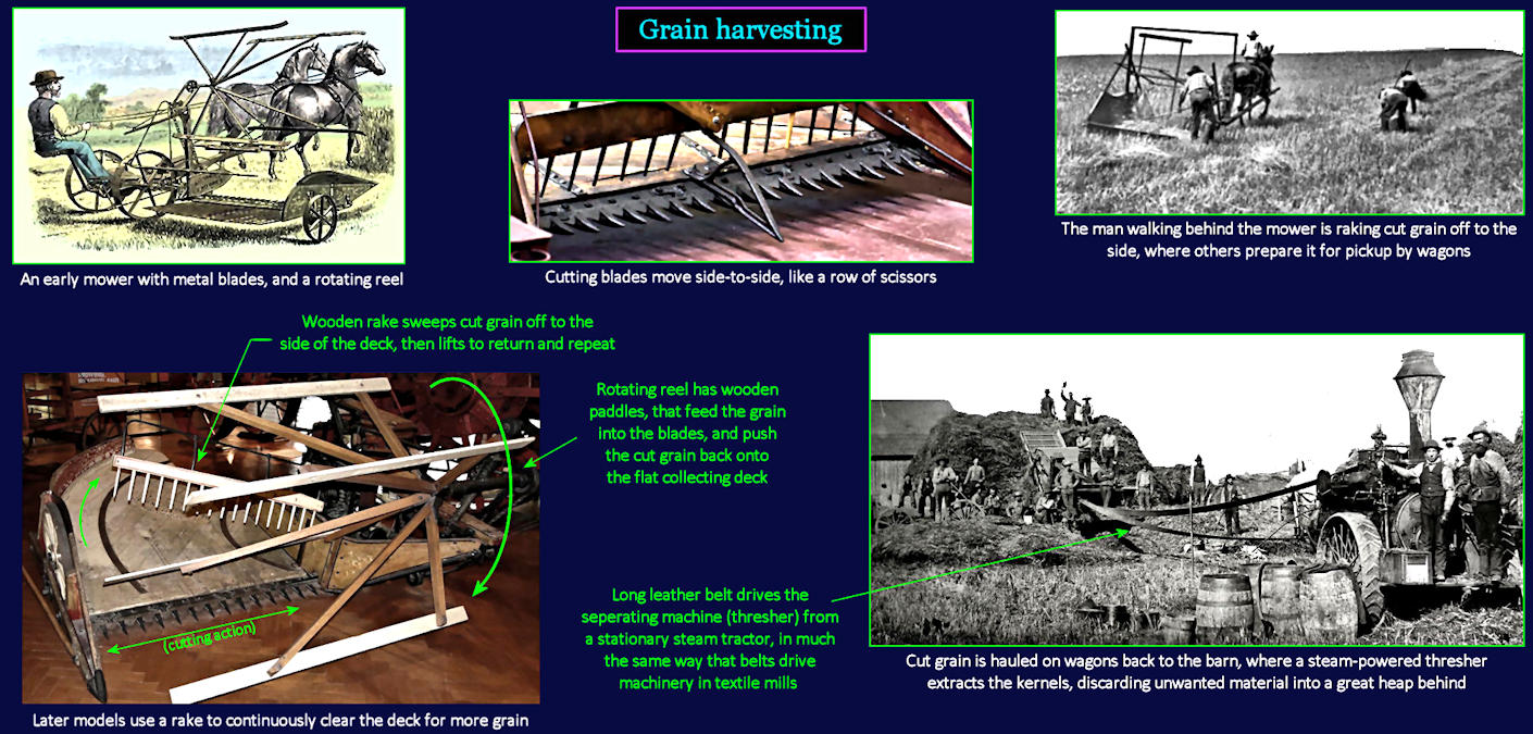
Simple Farm Mechines The equipment shown here (except at bottom right) illustrates the evolution of mechanical mowers, which replace hand-held scythes for cutting field crops like wheat, oats, rye and barley. Only the kernels (grain seeds) are desired, as these contain almost all the nutritional value. Kernels are extracted by a large, ungainly threshing machine (lower right). Powered by a steam engine, it beats the grain, discarding everything except the grain kernels that fall out below. The mountain of material behind it is straw, which is the fibrous stalk, used mainly as bedding for animals. Hay grown for animal feed doesn't go through this process, and thus retains its kernels. Later 'combine harvesters' combine the functions of mowers and threshers. | |||||||||
| |||||||||
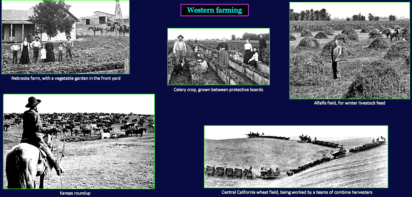
Anything and Everything The pictures across the top illustrate the range of farming activities in the prairie region, from small vegetable gardens to large field crops. The photo at bottom right is from the central California region, east of San Francisco. It shows the increasing scale of harvesting operations on western wheat fields. Few farmers can turn a consistent profit in this region, however, before large-scale irrigation projects are completed. | |||||||||
| |||||||||
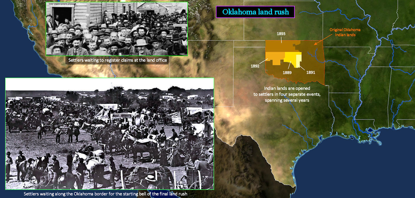
Indian Land for Sale The region which eventually becomes the state of Oklahoma is originally reserved as a dumping ground for Indian tribes removed from eastern states. Congress now responds to increasing pressure to open up even these lands to white settlement, and organizes four separate 'land rush' events over five years. The first land offered for settlement is right in the center of Oklahoma. Eager settlers arrive by train from Kansas, flooding in like a crazed mob. The final event involves land lying just across the border with Kansas. Settlers line up right on this line, waiting for the signal to begin their dash to claim a plot (lower left). Scroll down to see what happens next. | |||||||||
| |||||||||
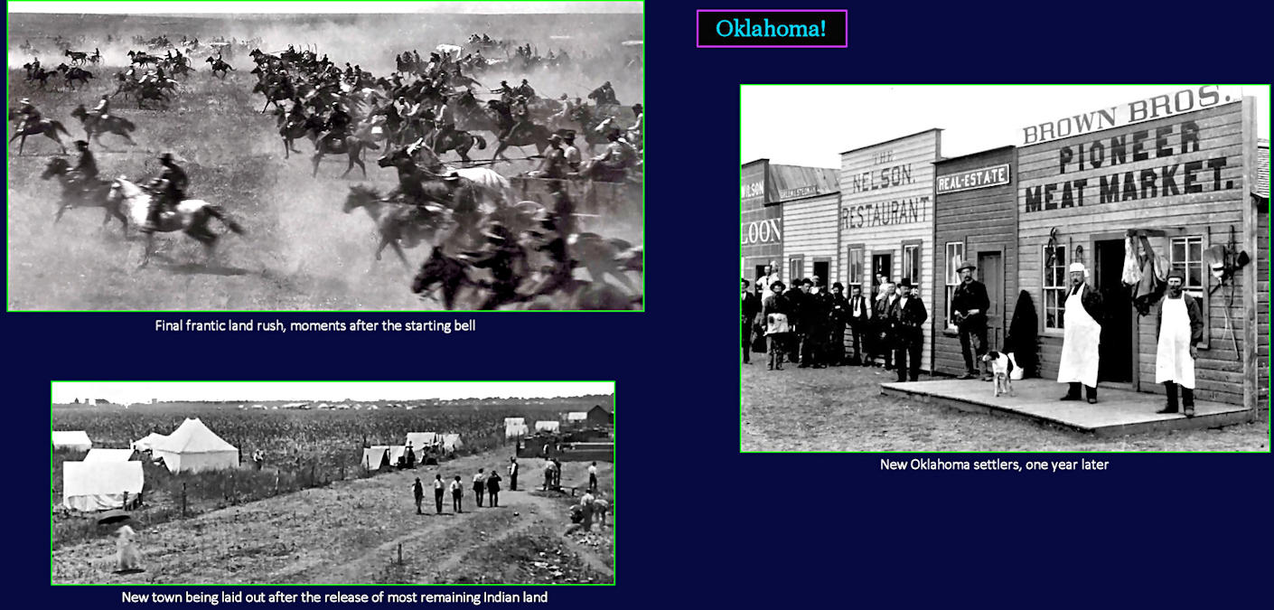
Grab Yourself a Plot The photo at upper left shows the stampede into Oklahoma during the final land rush, in 1893. Once settlers arrive, towns spring up almost immediately (top right). After considering the mayhem of this final rush, the government decides that perhaps this isn't the best way to release land. In 1901, it holds an auction to divide up most remaining Indian lands to settlers. This allows new towns to be laid out in a more relaxed manner (lower left). The only Indian tribe that never gives up its land in Oklahoma is the Osage. Its reservation remains today. | |||||||||